77 Seconds Over Greenacres: Part One
A Learjet carrying nine people fell from 35,000 feet in Palm Beach County. Here is what the flight data, the radar, the lightning record and the public record show, and what they don't.
This story is dedicated to the nine people aboard N722BD and to the families who lost them. The Despoiler will follow this investigation to its end, with one goal: that what killed them is understood and fixed. We will not publish graphic images or cockpit audio, and we will name the passengers and crew only when officials or their families do.
Editor's note
A note from Rich Vandall, editor
Within hours of Sunday's crash, video of the jet's final seconds and recordings of the crew's last radio calls were being broadcast by national outlets and widely shared online.
I found that coverage deeply troubling. Nine people died in those moments, and they have not yet been publicly identified. Replaying their final seconds adds little to the public's understanding of why this happened, and it can do lasting harm to the people who loved them.
It is 4 a.m. Monday as I write this. I have been working on this story since Sunday, when I came across the crew's final radio calls by accident on YouTube.
That is why The Despoiler is publishing this first installment now. It contains no crash video and does not reproduce or quote the crew's final transmissions. It reports what the public record shows, separates that clearly from what remains unknown, and examines the safety questions this crash raises. Further installments will follow as the investigation proceeds.
What happened
Nine people died Sunday when a Learjet 60 fell from 35,000 feet and crashed in a residential area of Greenacres, in Palm Beach County, Florida. It hit the ground at about 12:50 p.m., close to homes and passing cars. Early reports say no one on the ground was hurt.
The jet, registration N722BD, left Austin-Bergstrom International Airport in Texas that morning, bound for North Eleuthera in the Bahamas. Transportation Secretary Sean Duffy said all nine people aboard were killed. Officials have not released their names.
Palm Beach County authorities evacuated about 600 residents of a nearby mobile home community, and the road near the site was closed. The National Transportation Safety Board is leading the investigation, with support from the Federal Aviation Administration.
The last minutes
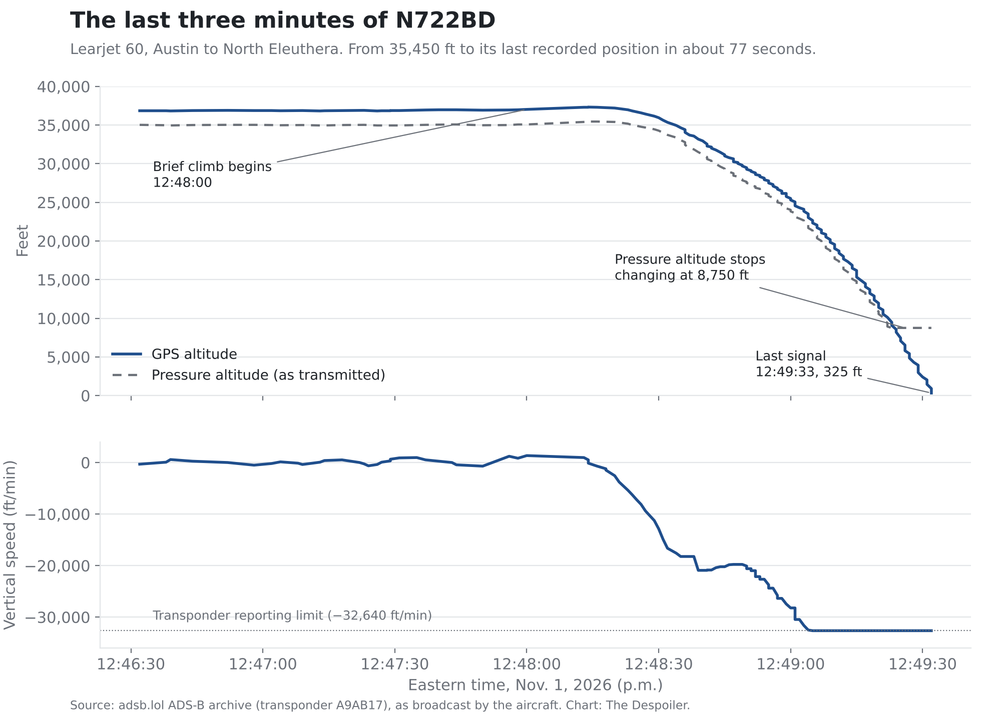
The jet went from the top of a brief climb to its last recorded position in about 77 seconds, according to transponder data The Despoiler pulled from the adsb.lol public flight archive. The data shows only what the aircraft broadcast. It does not explain why, and we will not guess.
The crew had reported turbulence, icing and precipitation at 35,000 feet and asked to climb, according to air traffic control recordings and flight tracking data reported by PBS NewsHour. The transponder data lines up with that account.
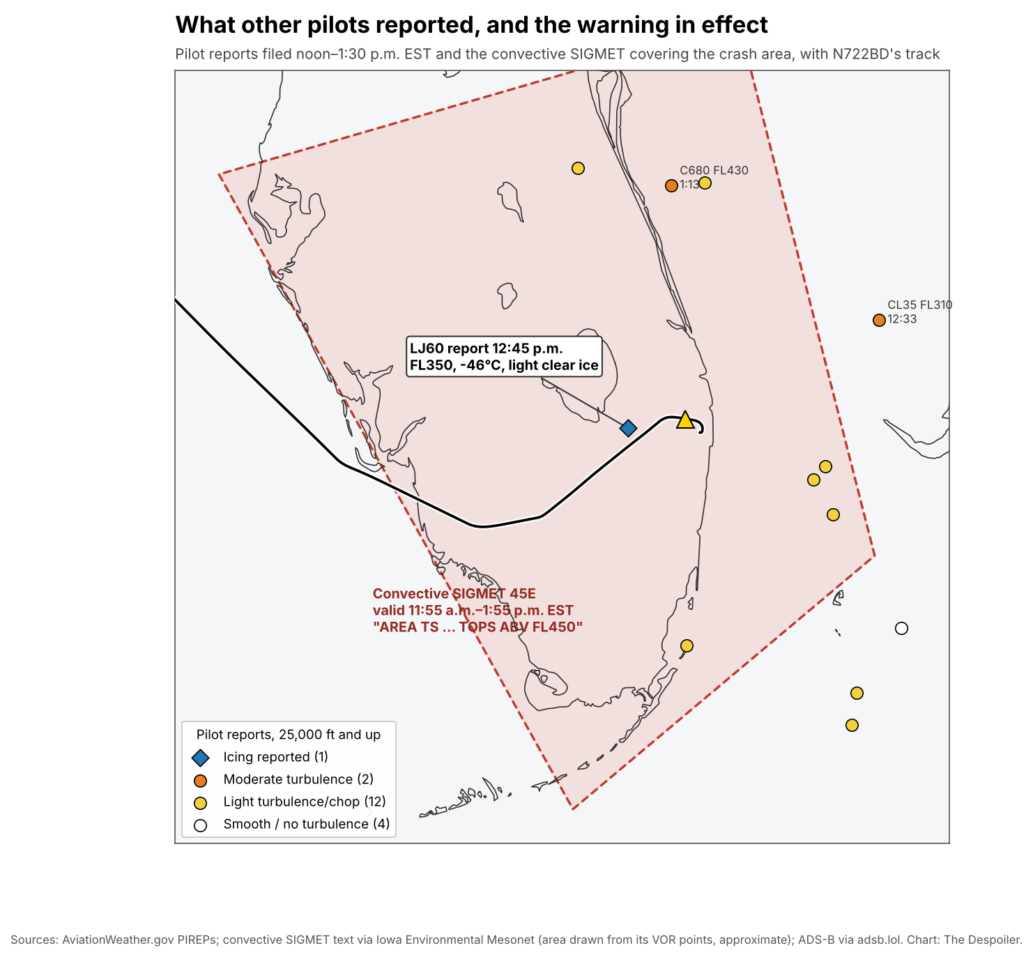
About three minutes before the dive, a Learjet 60 filed a pilot report with air traffic control: 35,000 feet, 25 nautical miles west of Palm Beach International Airport, an outside temperature of minus 46 degrees Celsius, and light clear ice. The FAA's public pilot-report log does not name aircraft, but N722BD's transponder put it at that spot, at that altitude, in that minute, so the report appears to have come from this crew. Airliners reporting from 35,000 to 37,000 feet within about 100 miles that hour described only light chop, and none reported ice.
| Time (EST) | What the jet's transponder shows |
|---|---|
| 10:37 a.m. (9:37 a.m. in Austin) | Takes off from Austin under its tail number, N722BD |
| About 11:03 a.m. | Levels off at 41,000 feet over the Gulf of Mexico |
| 12:37–12:43 p.m. | Descends to about 35,000 feet over the Everglades |
| 12:47 p.m. | Small altitude swings as the jet turns east toward the Bahamas |
| 12:48:00 p.m. | Begins to climb |
| 12:48:15 p.m. | Peaks at 35,450 feet |
| 12:48:16 p.m. | Starts down; passes 10,000 feet per minute within 12 seconds |
| 12:48:39 p.m. | Descending at about 21,000 feet per minute |
| 12:49:05 p.m. | Hits the transponder's maximum reportable rate, 32,640 feet per minute |
| 12:49:33 p.m. | Last signal, 325 feet above the ground over Greenacres |
The crew had asked to climb to 37,000 feet, according to the recordings as reported by Forbes. The jet gained about 450 feet before it started down.
During the dive the jet turned steadily to the right, about 190 degrees in all. The transponder code stayed on 4021, the routine code assigned for the flight, the whole time. The crew declared their emergency by radio.
In the final 10 seconds, the jet's reported pressure altitude stopped changing at 8,750 feet while its GPS altitude kept falling. That may reflect a sensor or the transponder's limits at extreme speed. Investigators will sort out what it means.
The GPS altitude shows how steep the end was. In the last several seconds the jet was losing roughly 5,000 feet every six seconds, more than 50,000 feet per minute, while its speed across the ground fell toward 240 knots. That combination means it was diving at an angle of roughly 60 degrees or more.
The broadcasts also carry quality flags for the jet's GPS position. Those flags stayed at their highest grade through the climb, the start of the dive and most of the fall, and dropped only in the last eight seconds, below about 9,000 feet. The data shows no sign of GPS jamming or spoofing before the jet began to fall. The transponder never switched to an emergency code.
The storm in its path
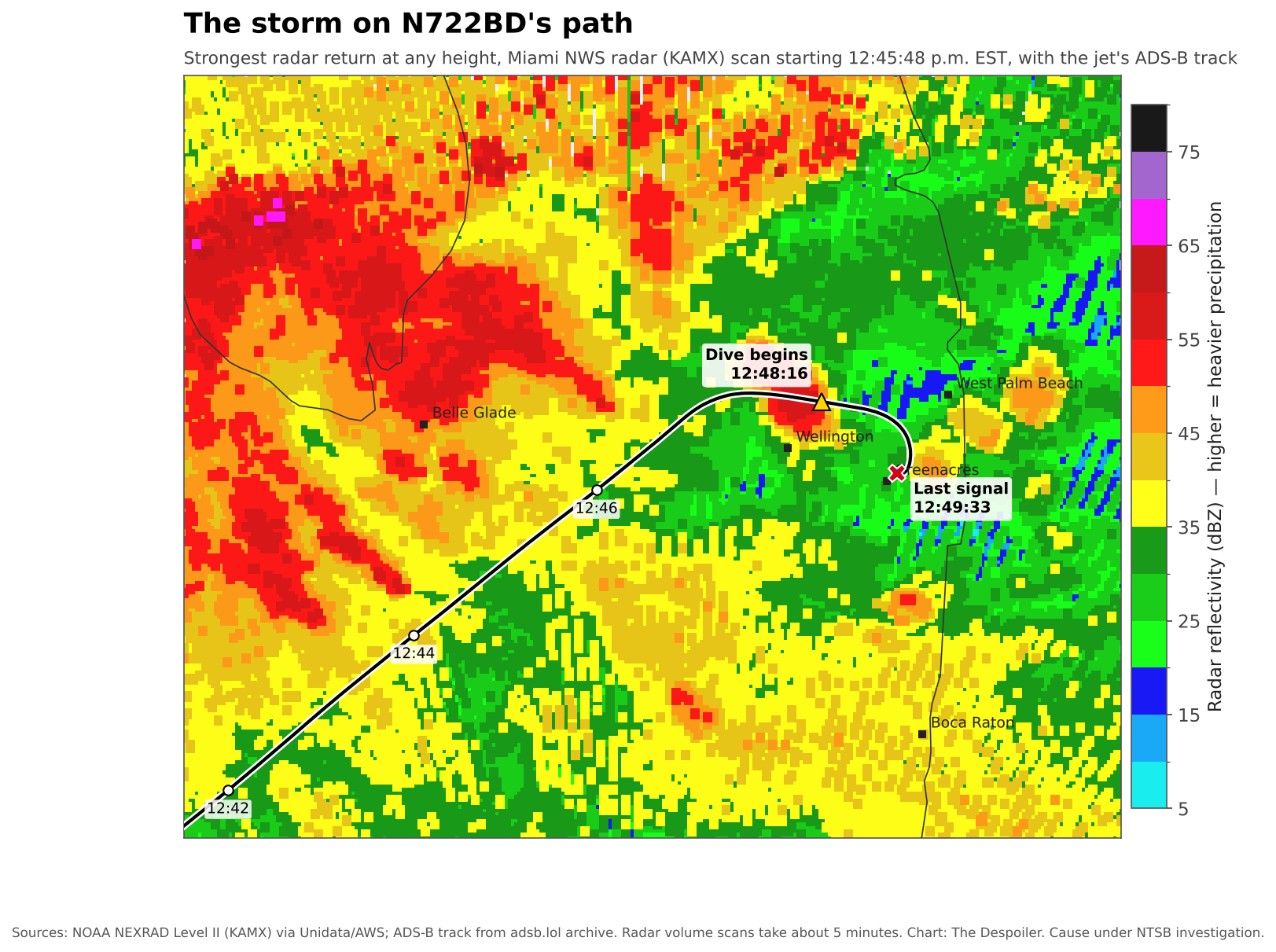
When the jet reached Palm Beach County, it was flying into an active thunderstorm warning. Two overlapping convective SIGMETs, the National Weather Service's in-flight warnings for thunderstorms, covered most of South Florida, including the jet's path: 42E, valid from 10:55 a.m. to 12:55 p.m., and 45E, valid from 11:55 a.m. to 1:55 p.m. Both warned of an area of thunderstorms with tops above 45,000 feet, about 10,000 feet higher than the jet was flying.
On the ground, the weather station at nearby Lantana airport reported thunderstorms in the vicinity at 12:35 p.m., with distant lightning to the west through the north.
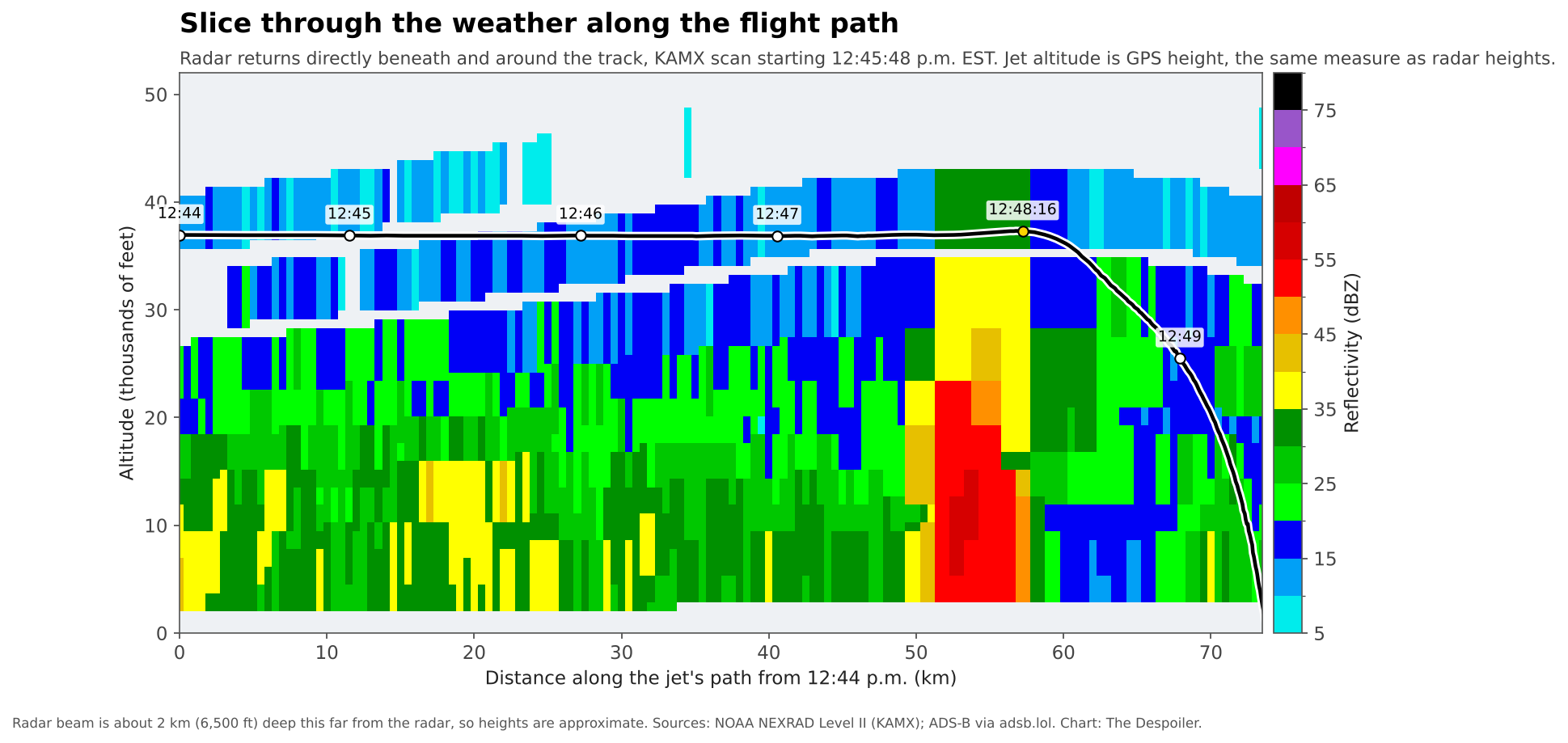
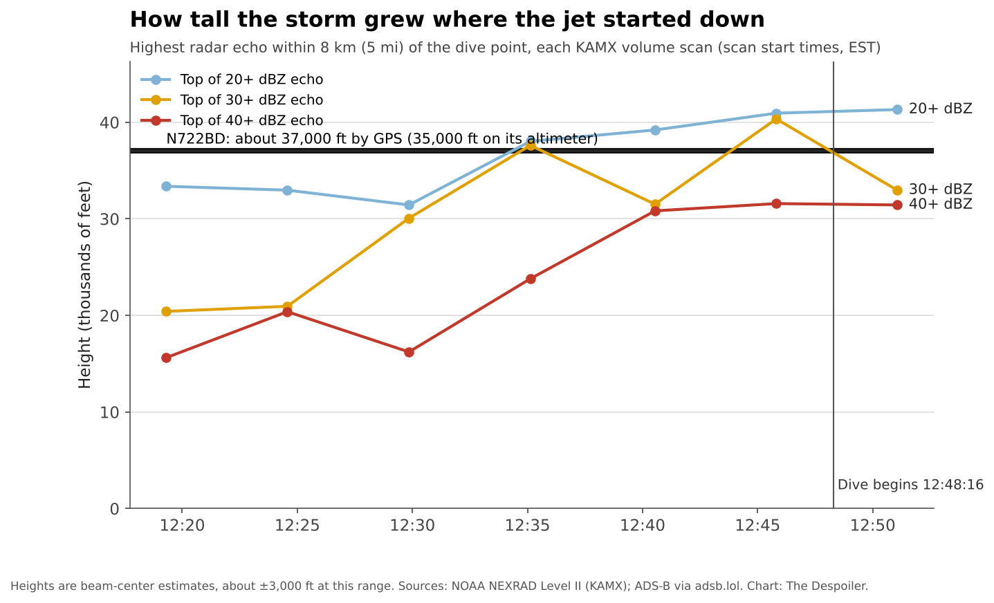
The Despoiler pulled the raw data from the National Weather Service's Miami radar for the half hour before the crash. It shows a compact storm cell directly beneath the point where the dive began, with its heaviest returns, above 50 dBZ, in the lower part of the storm. Within about 5 miles of that point, the top of the storm's 30 dBZ echo rose from roughly 20,000 feet at 12:19 p.m. to roughly 40,000 feet in the scan that began at 12:45. Radar heights at that distance are approximate, give or take about 3,000 feet. Even so, the weaker echo at the storm's top reached about 41,000 feet, above the jet's altitude. The jet was flying through the upper part of the storm, not over it.
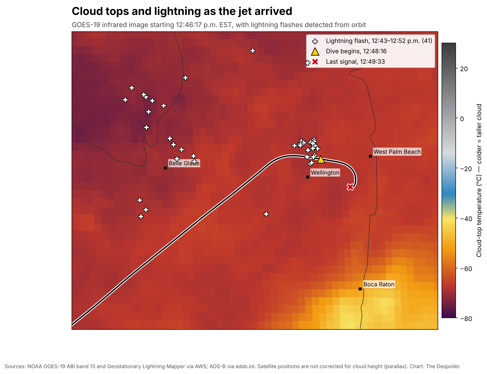
The storm was producing lightning. The Geostationary Lightning Mapper on the GOES-19 weather satellite recorded 28 flashes within about 6 miles of the dive point between 12:37 and 12:52 p.m., roughly one every 30 seconds. One came at 12:48:12, four seconds before the dive began. The public data does not show whether the jet itself was struck. Satellite infrared images show cloud tops over the area near minus 70 degrees Celsius, a sign of tall storm clouds.
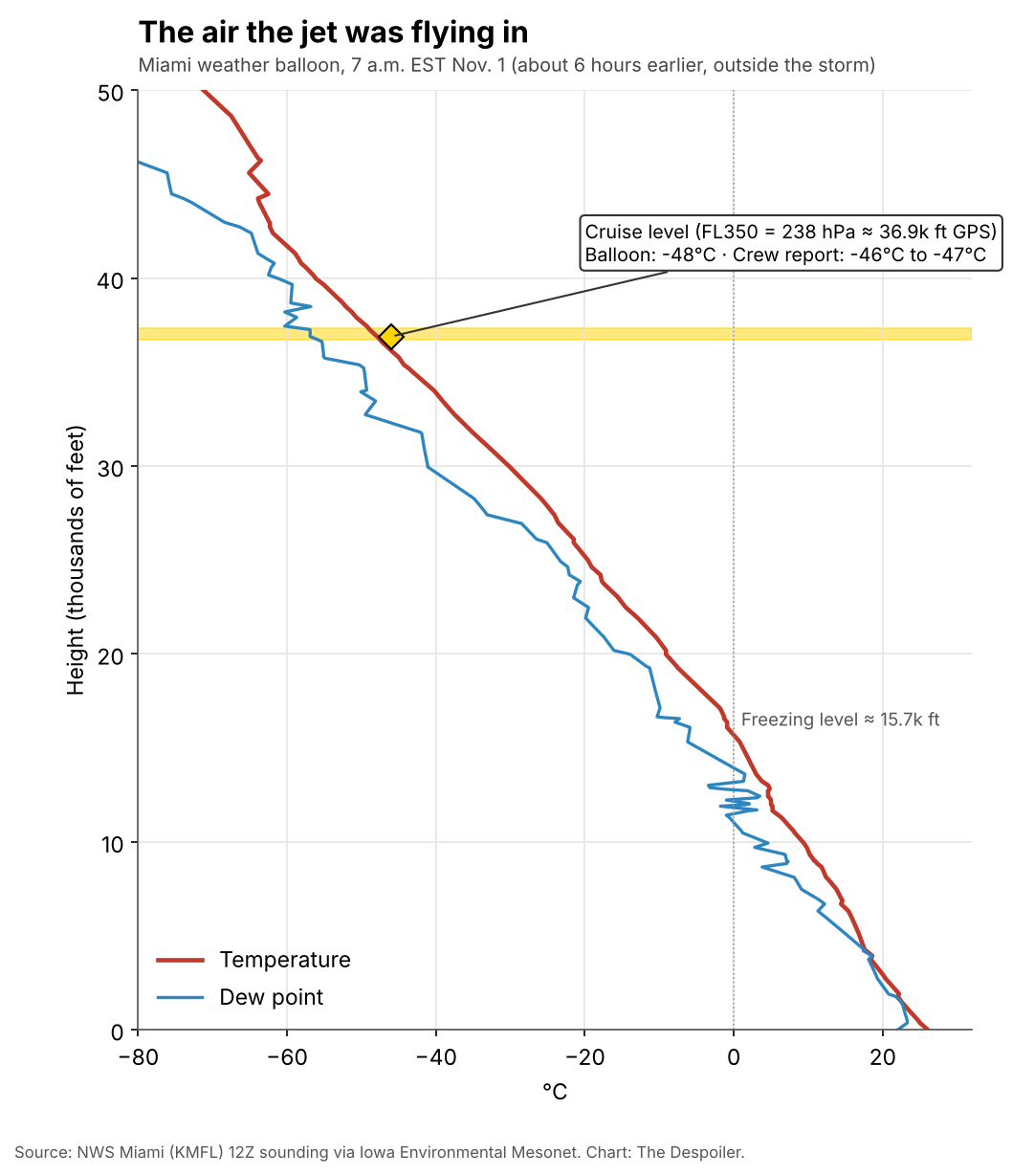
The air at the jet's cruising level matched what the crew reported. The Miami weather balloon launched that morning measured about minus 48 degrees Celsius at that pressure level, close to the minus 46 to minus 47 degrees the crew gave. Around the region, other pilots flying at 25,000 feet and above that hour mostly reported light chop. The only icing report at those altitudes was the Learjet 60's.
None of this establishes why the jet went down. Weather is one of many factors the NTSB will examine, along with the aircraft, its maintenance, its crew and how the flight was operated.
What the evidence rules out
Rumors about this crash spread quickly online. Here is what the public record shows about the most common ones.
- A missile or shoot-down. Much of this claim traces to Gov. Ron DeSantis saying the falling jet "looked like a missile going down," a description of how steeply it fell, not of a weapon. Aircraft struck by missiles at cruising altitude typically break apart in the air: their transponders go silent at altitude and wreckage scatters over miles. N722BD did the opposite. Its transponder broadcast a continuous track for the full 77 seconds, down to 325 feet above the ground, and it came down at a single site. The crew was talking to air traffic control during the dive, describing the jet's speed and descent. The flight restriction for the president's visit ended at 12:30 p.m., 18 minutes before the dive, and covered only airspace below 18,000 feet. The jet was at about 35,000 feet. No official has suggested the jet was fired on.
- GPS jamming or spoofing. The jet's GPS quality flags stayed at their highest grade until the last eight seconds of the fall.
- Weather modification. The storm grew over about half an hour, inside an area where the National Weather Service had already warned pilots of thunderstorms, as South Florida storms routinely do. Florida has banned weather modification since July 2025.
- Lasers, microwaves or other "directed energy" weapons. Publicly known systems built to stop drones work at ranges of a few miles at most, and laser beams lose much of their power in rain and cloud. The jet was inside a thunderstorm at 35,000 feet, and its electronics kept transmitting normally through the dive.
What remains is the ordinary, unresolved question at the center of every crash investigation: what the weather, the aircraft and the crew's actions each contributed. That is for the NTSB to determine.
Private flight, charter jet
N722BD is cleared to fly paying passengers. The FAA's public list of legal charter aircraft shows it on the Part 135 certificate of Aurora Aviation, Inc., as serial number 271. The current version of that list is dated Oct. 26, 2026, six days before the crash.
FAA registration records list the owner as LR60271 LLC, a company named for that serial number, at 1209 N. Orange St. in Wilmington, Delaware, a registered-agent address shared by a vast number of companies. The current registration was issued Jan. 4, 2023, and runs through Jan. 31, 2030. The record names no other owners. Officials have described Sunday's trip as a private flight. The crew used the tail number as its radio call sign, which is common for private flights but also used by small charter operators.
Aurora flies eight aircraft on that certificate, three of them Learjet 60s, according to the same FAA list. (A separate company, Aurora Aviation, LLC, holds a different certificate.) CNN reported the jet was listed online for charter through Jettly. A spokesman for Austin-Bergstrom described N722BD as a private aircraft, according to IBTimes UK, and the FAA has classified the crash as general aviation.
The difference matters. A charter flight (Part 135) must meet stricter rules on pilot training, rest and company oversight than a private one (Part 91). Whether this trip was flown as a charter, and whether anyone aboard paid for it, has not been confirmed. The NTSB's preliminary report should say which rules applied. Neither Aurora Aviation nor LR60271 LLC has commented publicly.
The safety gaps
We don't yet know what brought N722BD down. We do know where federal safety rules for private and charter jets have stalled for years, often over cost.
No black box required. Since 2016 the NTSB has asked the FAA to require flight data recorders on all charter aircraft. It has repeated that call five times, including after the 2020 helicopter crash that killed Kobe Bryant. The FAA still has not required it. The NTSB says 83% of the fatal crashes it investigated from 2005 to 2020 involving private and charter turbine aircraft had no recording equipment at all.
Industry pushback. The business aviation trade groups NBAA and NATA opposed a 2007 recorder rule, with NBAA estimating its cost to private and charter operators at more than $1 billion. In 2021, NBAA told the FAA a requirement for flight data monitoring would be too costly for most charter operators.
Recommendations left waiting. Since 2000, nearly a quarter of NTSB recommendations to the FAA ended with what the NTSB called unacceptable action, according to an InvestigateTV analysis. FAA replies the NTSB rejected mentioned cost at least 90 times.
Slow progress. The FAA required safety management systems for charter operators in 2024. Operators have until May 28, 2027, to comply.
Protection that exists but isn't on these jets. Newer flight decks can stop a pilot from overspeeding, stalling or spiraling. Garmin's version is called ESP. Retrofits have started bringing newer protections, including emergency autoland, to older turboprops like the King Air 350. The Despoiler found no such retrofit offered for the Learjet 60.
What comes next
This is part one. The NTSB is scheduled to brief reporters Monday in West Palm Beach, and part two will follow what investigators say there.
Our follow-up will also look ahead. We will report on what can prevent accidents in conditions like these: the technology, training and weather-avoidance practices that experts and investigators point to. We'll lay out the path to putting them in place, including who has to act and what it would cost. And we'll identify the pending legislation and proposed federal rules that readers can follow, support or comment on.
The NTSB usually publishes a preliminary report within about a month and a final report a year or more later. The Despoiler will cover both and keep asking:
- Was this flight operated under charter rules or private rules, and who operated it?
- Did anyone aboard pay for the trip?
- What did the jet's weather and icing conditions look like at 35,000 feet, and what did the crew know before they got there?
- Did N722BD carry a flight data recorder or cockpit voice recorder?
- Which open NTSB safety recommendations, if adopted, would have applied to this flight?
Readers can comment on FAA safety rules when they're proposed at regulations.gov, and can contact their members of Congress about the NTSB's open recommendations. Tips go to The Despoiler at thedespoilerdayton@proton.me or on Signal.
Sources
- PBS NewsHour: All 9 people aboard a jet that crashed in Florida have died
- CNN via KESQ: Learjet crash in Florida kills all 9
- Forbes: Pilot reported icing before deadly Florida Learjet crash
- IBTimes UK: Was Florida crash jet N722BD a charter flight?
- FAA: Certificated Part 135 operators and aircraft
- FAA aircraft registry: N722BD
- adsb.lol flight history archive (raw ADS-B data)
- NOAA NEXRAD Level II, KAMX Miami radar (raw data)
- NOAA GOES-19 ABI and Geostationary Lightning Mapper (raw data)
- AviationWeather.gov: pilot reports (PIREPs)
- Iowa Environmental Mesonet: SIGMET archive, Lantana METAR and Miami sounding
- FAA: Temporary flight restriction FDC 6/3803 (Palm Beach VIP)
- WLRN: Florida enforces new law banning weather modification
- NTSB: Install crash-resistant recorders
- InvestigateTV via Atlanta News First: Safety improvements left in limbo
- AIN: NBAA and NATA criticize recorder proposal (2007)
- AIN: NBAA cautions FAA on Part 135 SMS proposal (2021)
- Federal Register: Safety management systems final rule
- GlobalAir: SMS deadline is May 28, 2027
- AIN: Garmin ESP
- AIN: Stevens performs first King Air 350 autoland install